 Tweet
Tweet
The updated track that they are predicting..
-
-
Updated info..Comment
-
and updated infrared satellite pic..Comment
-
I was just checking those Cayman Island weather stations you posted, Steve.. couldn't stop staring at this stat:
SIX FRICKEN FEET of rain!Rain Today : 72.74 in
Comment
-
Must be some kind of misinformation there Kv...Comment
-
Perhaps, perhaps not...
Weather Conditions at ZF1RC, South Sound, Grand Cayman
19° 16' 24" N, 81° 23' 06" W
At: 09/12/04 8:10a
Temperature: 83.4°F Wind Chill: 83.4°F
Humidity: 98% Heat Index: 99.9°F
Wind: W at 0.0 mph Dewpoint: 82.8°F
Barometer: 973.3 mb Falling Rapidly
Rain Rate: 15.16 in/hr
Today's Rain: 72.74 in
Monthly Rain: 77.02 in
Storm Total: 77.01 in
Yearly Rain: 89.23 in
Last edited by Greebe; 13 September 2004, 00:52."Be who you are and say what you feel, because those who mind don't matter, and those who matter don't mind." -- Dr. Seuss
"Always do good. It will gratify some and astonish the rest." ~Mark TwainComment
-
Slowly it moves.. but now actually turning a bit more northward. Amazing how relatively unchanged this has remained in its strength over the past few days.Comment
-
Now entering the Gulf of Mexico. The outer bands of this system extend from Honduras to Georgia. I wouldn't want to be on the western tip of Cuba. It doesn't look too hospitable right now.. Last edited by KvHagedorn; 13 September 2004, 20:19.
Comment
-
Damn! The best cigar tobacoo plants in the world are right there. Any thing but that!!!Originally posted by KvHagedorn
... I wouldn't want to be on the western tip of Cuba. It doesn't look too hospitable right now..
<TABLE BGCOLOR=Red><TR><TD><Font-weight="+1"><font COLOR=Black>The world just changed, Sep. 11, 2001</font></Font-weight></TR></TD></TABLE>Comment
-
We had a wonderful Ivan inspired sunset this evening. Caught 4 largemouth bass >8lbs each too "Be who you are and say what you feel, because those who mind don't matter, and those who matter don't mind." -- Dr. Seuss
"Always do good. It will gratify some and astonish the rest." ~Mark TwainComment
-
Well, it has weakened quite a bit. 140mph now, down from 160. They do say there is a chance for strengthening again tomorrow before it makes landfall though.Comment
-
The satellite picture doesn't look quite as fearsome now, but you can still see that huge eyewall.. the eye itself was reported as 43 miles wide earlier. If this strengthens to category 5 again, we are looking at what is essentially an F3 tornado 50 miles wide.. perhaps hitting New Orleans.
Comment
-
This part of the storm's track is remarkably like Camille's in 1969. That was the most intense storm to strike the U.S. mainland in recorded times. This storm had 165mph winds with 200mph gusts, and a storm surge of 25 feet. The Mississippi coast and New Orleans area are supposedly much more susceptible to storm surge. They reported tonight that if this hits New Orleans as a Category 5, the surge could be 33 feet. For a major city 10 feet below sea level.
Here is Camille's track:
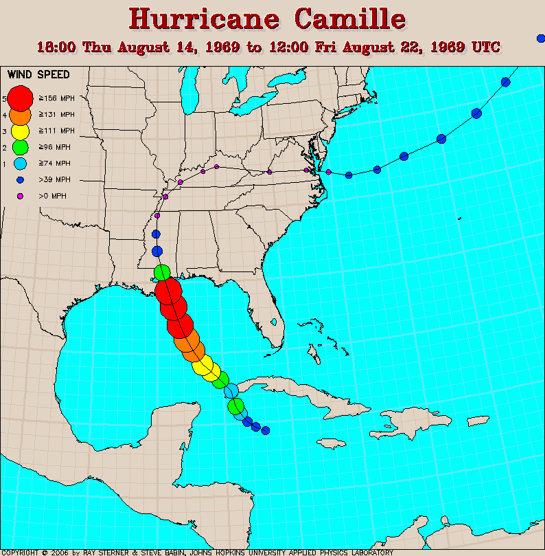
It's pretty similar to Ivan's, but did not really explode into a major hurricane until it was past Cuba, so it caught people a bit by surprise. No one at that time really knew what such a monster would do, either, and there were actually people having a hurricane party in an apartment house on the beach when it hit. The whole complex was washed away, and only one survivor was found.. a woman who somehow found something to hold onto and was found floating a couple of miles inland.Comment
-
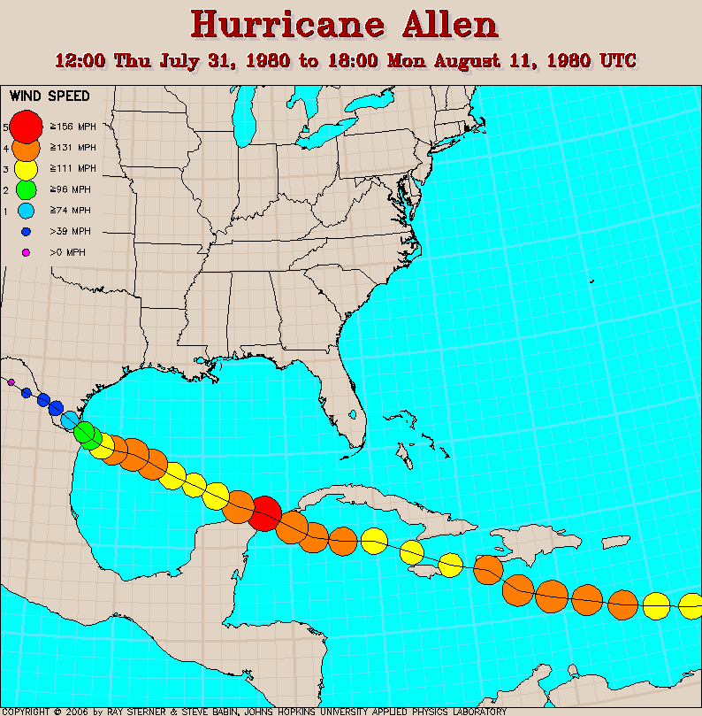
This is a good page for looking at the behavior of several notable recent hurricanes. I remember this one in particular, and it is similar to Ivan in that it held its strength for a very long time, which is extremely unusual. People were talking about it for many days before it came close to making landfall, and it was a huge storm, practically covering the whole Gulf of Mexico with its cloud system. Everyone expected it to slam the lower Rio Grande Valley and wipe out everything in its path, but just before it could land, it slowed down and stopped, losing most of its strength before moving ashore.
 Last edited by KvHagedorn; 14 September 2004, 21:06.
Comment
-
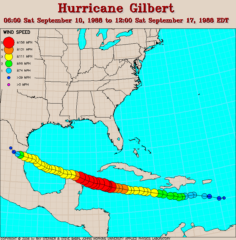
This is the most intense Hurricane ever recorded in the Atlantic basin. At its peak strength, Gilbert had an internal pressure of 888 millibars and sustained winds of 185mph. Notice the storm remained a category 5 for some distance inland after making landfall in the Yucatan. I remember the eerie wind that passed through here after it had supposedly blown itself out.. a sustained wind of about 30mph.. after it had been inland for 3 days or so. Momentum counts.
Comment

Comment